1st November 2015
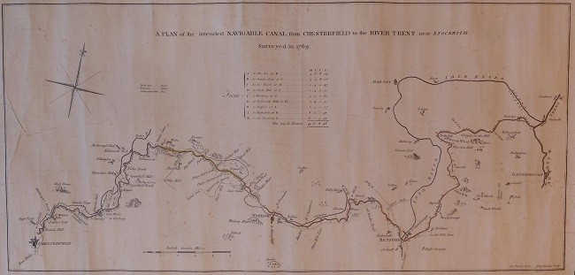
Easily the most popular pages on this website are the maps ones, so lots of you will be delighted to know that yet another map has come to light.
This one is very similar to the 1769 John Varley map ending up in Gainsborough (click here). This is not surprising, since both were engraved by Thomas Kitchin – see bottom right corner.
The main difference is that this is, more or less, the actual route adopted.
This is much larger than other maps. (The map itself is 800 mm x 380 mm; the piece of paper is 950 x 490.) This means that it has more detail than other maps.
An intriguing feature is a series of numbers. These go from 1 (at Chesterfield) to 174 (at West Stockwith). They are not evenly spaced. They are very crowded together in Chesterfield and very spread out near Osberton.
As ever, we turned to Christine Richardson, our historian, who writes
“The numbers on the maps are packets of land, usually in that era called ‘Closes’, each having a name. The relevance to the canal is that different landowners are involved, some of whom agree with building a canal through their land, others who don’t. They are more tightly packed in areas where there are more people and ‘closes’ have probably been divided on the owner dying. In rural Nottinghamshire the ‘closes’ are still larger in size.
There was originally a book, produced by the Canal Company, identifying the numbers on the maps to ownership. But, unfortunately, that book has yet to come to light, or has been destroyed.
It was all relevant during the application for the Act of Parliament, with the Canal Company having to prove, to the owners and Parliament, through whose land they were going to build the canal.”
We are massively grateful to Liz Portas who bought the map. She found it online. It came from a dealer who got it from the Yorkshire Archaeological Society which was downsizing its library.
To see our other historical maps, click here.