

Section 1: Colliery Link
This runs from Eckington Road Bridge at Hartington in Staveley to Spinkhill Lane in Renishaw. It joins the sites of the old Hartington Colliery and Renishaw Colliery.
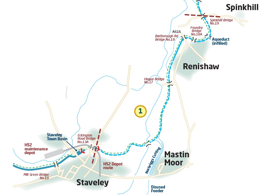
After Eckington Road Bridge, the canal is crossed by the former railway line from Barrow Hill to Clowne. The ground levels here have been severely affected by mining subsidence and a new passage under the railway requires “fall and rise” locks on either side to reduce the pound level and accommodate the requirements of the lower rail level. Staveley Town Lock was completed in 2016 to drop the pound.
This crossing is now proposed to be used by HS2 as a link to their proposed Infrastructure Maintenance Depot on the old Staveley Chemical Works site west of Hall Lane. Discussions with HS2 engineers are ongoing to assess any further design requirements and changes.
Once clear of the bridge the canal reaches the “riser” lock, Railway Lock, which returns to the previous water level. The link between the Trans-Pennine Trail and the Arkwright Trail will cross the canal on a new high-level multi-user trail bridge, which will cross east of the lock.
Continuity of water supply to the north and east of the dropped pound will be maintained by a siphon pipe between the two higher sections.
Bellhouse Basin at the bottom of Bellhouse Lane will be reused. This short length will have wash walls on both sides and hard, paved edges, mooring rings/bollards and is designed to provide short term moorings. There will be interpretation boards to tell the story of the basin, its tramway links to Inkersall, the gas works and the archaeological dig by the Chesterfield Canal Trust in 2017 which found three old boats.
Access to the farm fields north of the canal will be provided by an accommodation bridge. This will also provide additional walking and cycling access to the Trans-Pennine Trail from Mastin Moor and Lowgates.
Staveley Puddlebank has been ravaged by subsidence and was bulldozed in the 1970s. The rebuilt Puddle Bank will have three elements: an earth-cored embankment on the west flank of the Doe Lea, a steel trough aqueduct over the river and a further length of earth-cored embankment on the eastern valley side.
Originally the Doe Lea passed under the Puddle Bank in an oval stone and brick culvert. This was removed in the 1970s to leave a sizable cutting through the bank. The river will now be crossed by a new aqueduct.
On the eastern side, a new side weir, discharging into the river, will be built on the north side of the canal opposite the original junction with the Norbriggs Cutting.
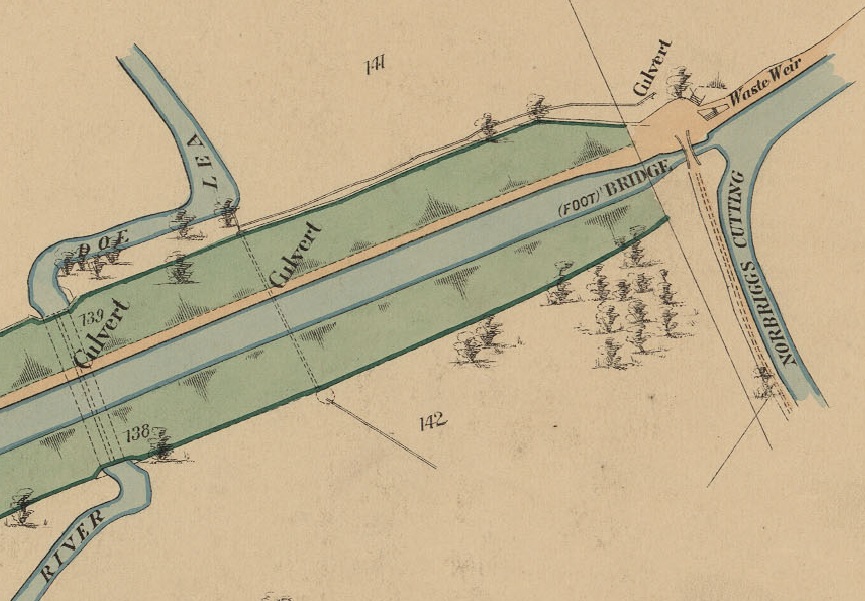
Doe Lea crossing and Norbriggs Cutting in 1892
The canal now turns north and reaches the site of Red Bridge which was entirely removed in the 1970s. The new bridge will be a flat-decked concrete beam bridge.
A new Hague Lane Bridge will be required for the infrequent HGV traffic to Staveley Sewage Works. The canal track will be diverted upslope, to the east, to provide sufficient water and towpath headroom clearance.
At the site of the former Miners Crossing, the bridge narrows have been built by the Chesterfield Canal Trust’s Work Party and have been backfilled to await the bridge deck.
The section of walling on the towpath side just south of Barlborough Road Bridge will be taken down and the canal will be widened to allow passage of 70’ boats and give room for moorings.
The channel after Barlborough Road Bridge was completely excavated in 2007/8 and Renishaw Foundry Footbridge was installed. Further east, secure deep piling (to bedrock) of both banks was carried out in 2008 prior to reinstatement of the canal channel.
This area has not suffered from the extremes of mining subsidence seen elsewhere and the channel will be excavated and re-used. A former lay-up basin will be reopened and engineered as a full length winding hole and reedswamp/wetland nature reserve.
A weir and water control features will be incorporated into this length to permit discharge of excess water back into the River Rother via the Smithy Brook.
Spinkhill Lane Bridge was dropped and infilled in the 1970s, although significant elements of the wing walls and abutments remain. The intention is to cosmetically integrate these elements into a new thin deck.
Section 2: Great Central Railway Mile
This runs from Spinkhill Lane along the 1890s diversion constructed by the adjacent railway (once the Great Central Railway, now the Trans-Pennine Trail) to Boiley Old Bridge.
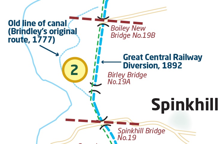
Spinkhill Wharf, north of the bridge will be reinstated for use as short stay moorings.
The canal then reaches the junction of the 1777 Brindley route and the 1890s Railway diversion. The diversion turns sharply north and enters a cutting parallel to the former railway line, now the Trans-Pennine Trail. The canal will follow this route and the original line, known as the Brindley Loops, will be opened as a walking route with detailed interpretation.
Short-term moorings will be built between Rabbit Lane Quarry and Birley Bridge for those wishing to explore the original canal line.
The next section is in good condition. The most interesting feature is Spinkhill Narrows, which was used to feed water to a trough for express trains on the adjacent railway line.
Boiley Old Bridge also spans the canal and the Trans-Pennine Trail.
Section 3: Forging into Killamarsh
This runs from the end of Railway Mile to Walford Road in Killamarsh via Forge Bridge.
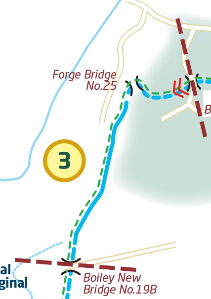
A short distance north from Boiley Old Bridge two short lengths of the channel were excavated to a navigable profile to create fishing ponds in the 1990s.
The length of water is divided by an earth bund which carries the Public Right of Way from Killamarsh to the TPT. This is the site of Gallas Footbridge which will be reinstated using the standard design.
At the north end, the canal is infilled for several hundred metres. Parts of the original course have been built over by the main access to, and further car parking for, the commercial fishing ponds.
The canal will pass through a short concrete box culvert – required to maintain the access road to the fishing ponds – and then under Forge Bridge, which is infilled but the arch and parapets are intact and it proposed to re-use the structure after excavation, recording and refurbishment.
Old Hall Farm Lock and Walford Road Lock will be built east of the old Lancashire, Derbyshire & East Coast Railway Bridge to lower the canal sufficiently to pass under Walford Road. There will be a spillway a weir and a wetland pond.
Section 4: The Crowning Glory
We expect this to be the last section to be delivered, hence its name, also inspired by the winning boat lift idea (see below).
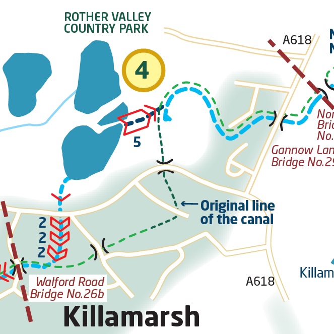
In the 1970s house building took place on part of the original canal line through Killamarsh. Given the aim to create the Rother Link, the new route goes down into Rother Valley.
Beyond Walford Road, the canal channel will emerge in a cutting, crossed by New Leah’s Bridge (foot and cycle), but will soon turn north down a wide area of grassland left following the rebuilding of the adjacent Bungalows housing estate.
There will be three pairs of double locks (Killamarsh Top Double, Middle Double and Bottom Double Locks) to take the canal down to Quarry Lane and under Sheffield Road in a box culvert. This will require the demolition of two semi-detached houses on Sheffield Road which the Chesterfield Canal Trust has purchased. To see this section in more detail, click here.
A short length of new canal will bring the channel to the Flood Defence bank in Rother Valley Country Park. A flood control lock will incorporate a guillotine gate which can be remotely controlled in conjunction with the Rother Valley flood defence system.
Eventually quiet moorings will be built in the lake on pontoons
The new route leaves the eastern side of the lake via a short length of new cut under Barber’s Lane Bridge, a new minor road bridge, before reaching the bottom of the Moorhouse Flight which raises the canal back to the original line of the canal.
The Moorhouse Flight consists of six locks – a five-rise group followed by a short pound and then a single lock at the point where the new route rejoins the original canal line.
The Moorhouse Flight has the potential to be an additional tourist attraction. However, an alternative would be to build a boat lift. To that end, the Chesterfield Canal Trust asked students from Nottingham Trent University to come up with some proposals. The winning idea was called The Crown. Such a lift would require major works such as car park, Visitor Centre, Café etc. To read more about this, click here.
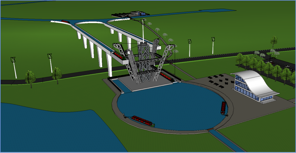
Back-pumping will be required on the flight. This need not be nearly such a major undertaking if the boat lift is built because it would use far less water.
A foot and cycleway bridge over the short pound will connect the original towpath line to the new towpath.
From Moorhouse Junction southwards the original canal will be reinstated and a winding hole constructed at the southern end adjacent to Primrose Lane.
The new bridge under Rotherham Road (known as Gannow Lane Bridge) will require only a modest increase in the road level to achieve a navigable height passage under the A618. Beyond, to the Grade ll listed Norwood Bridge, the canal is silted in places but otherwise retains water.
Section 5: The Cradle of the Canal
The Norwood Flight is the most important built heritage on the yet to be restored canal and is arguably the most important on the entire navigation. The 13 locks lift the canal 76 ft in just under ¾ mile and are an as yet unsung wonder of the early canal age.
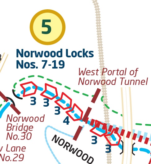
They are arranged in four staircases consisting of a three-rise, a three-rise, a three-rise and a four-rise. These are separated by three ponds and side-ponds which regulate flow and provide water storage.
Work to restore the flight to its last operating condition will commence with detailed archaeological investigation and mitigation works to protect the flora and fauna. The weirs and infilling will be removed and the lock walls stabilised using the techniques successfully applied to the Thorpe and Turnerwood Flights. Repairs to the fabric of the lock chamber will utilise heritage materials and methods.
Minor repairs are required to Norwood Bridge at the bottom of the lock flight and entirely new accommodation bridges will be required to provide access to the private houses at the top and bottom of the flight. It is likely that a lift or swing bridge design will be necessary at the upper site.
The feeder leat from the Woodall and Killamarsh Ponds will need to be re-engineered due to subsidence as will the ponds themselves.
In addition, water will continue to be received from drainage and the remains of the tunnel. Further water will come from groundwater sources and the new summit level.
Section 6: Up or Under
This section commences at the Western portal of the Norwood Tunnel and extends eastward to the western edge of the former Kiveton Colliery Site.
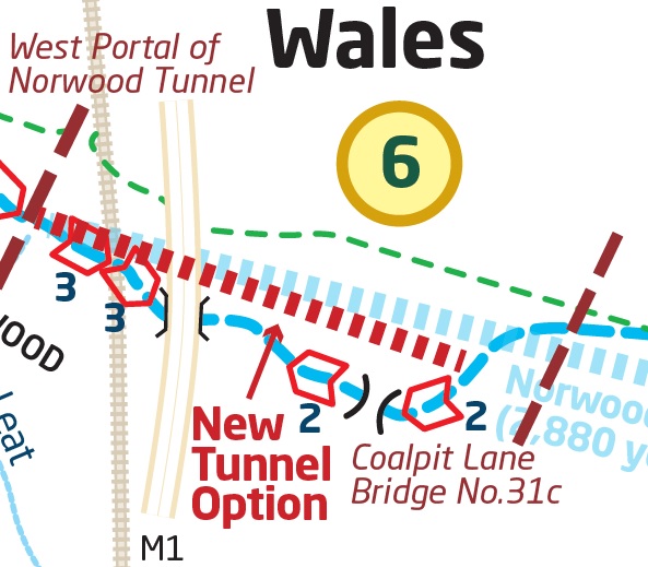
The major problems facing this length are the replacement of the collapsed Norwood Tunnel, achieving a passage under the M1 Motorway which now runs above and across the tunnel site and the vast new embankment that will be built for HS2 on the west side of the M1.
There are two plans – either to lock up to the motorway and use an existing culvert or to build a new tunnel, avoiding the need for locks.
The current plan for this section has a new length of canal channel leaving the original line on the off-bank around 75 m from the standing Western Portal of the Norwood Tunnel carried in a shallow cutting to the south of the tunnel entrance wing wall.
The towpath will be carried up and around the top of the original Norwood Tunnel before rejoining the north bank of the waterway.
After 50m the cutting will deepen and enter the first of the Norwood Extension Locks which consists of two three-rise locks – the Norwood High Treble and Top Treble Locks. At the top of the second group the canal turns north-east and reaches the west entrance to the farm underpass below the M1 Motorway.
On the eastern side of the motorway the canal runs for a short distance in a shallow cutting. A foot and cycleway bridge over the canal maintains rights of way connectivity.
The new summit pound will be relatively short. To increase water storage two new side ponds will be created on the off bank. The ponds will link, via separate feeders, to the main canal channel to the east and west of a single flood-gate/lock gate.
Beyond the ponds, at the eastern end of this short summit pound, the canal will run onto a short length of low embankment before descending a two-rise staircase lock.
At the tail of the lock flight a minor bridge will carry Coalpit Lane over the canal. The route them follows a gently sinuous course across a relatively level area following the edges of the existing field layout.
At the western edge of the former Kiveton Colliery Tip the canal descends via two staircase locks – the Wales Double Locks. Below the locks the canal will be at the Kiveton Waters pound level.
A tail-bridge below the locks (Wales Bridge) provides a foot and cycle-path connection between Wales/Kiveton, the community woodlands and Harthill. At this point drainage for the tip is received having been filtered in a reedbed to remove sediment and improve water quality.
The alternative plan to get through this section is to build a new tunnel. This would be approximately 630m in length – interestingly about the same length as that originally proposed by James Brindley. The tunnel would run from just south of the existing western tunnel portal and emerge at Coalpit Lane. To read more about this, click here.
There would be no need for back pumping. The canal would maintain a level below that of the feeder which currently runs across the top of Kiveton Waters.
Section 7: The Tunnel Reborn
This section runs from the western limits of the Kiveton Country Park to the existing canal at the eastern portal of Norwood Tunnel.
The canal channel skirts the north-west boundary of the former colliery tip utilising the line of an existing trackway and drain before entering the former colliery site itself.
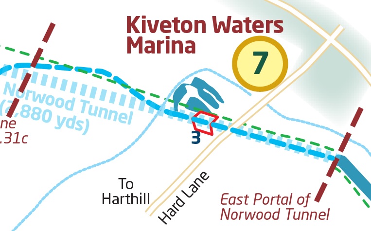
The route within the Kiveton Colliery site has already been defined by the construction of a canal channel and deep cutting built when the landscaping of the former colliery site was undertaken by English Partnerships. At the same time three large ponds, Kiveton Waters, were constructed on the colliery site at the summit level with the intention that they can be converted into a marina once the canal is restored. In the interim they are let as fishing ponds.
Joining Kiveton Waters and the national network will involve use of the eastern surviving fragment of the Norwood Tunnel. This was inspected by the Canal & River Trust in 2016. It was found to be intact and in good condition for a distance of around 470m from the East Portal. The first blockage occurs just to the east of Hard Lane.
The link will be made by excavating a large cutting to the west of Hard Lane, within which a three-rise staircase lock will lower the canal to the tunnel pound level followed by a full-sized winding hole. This will be used by the Chesterfield Canal Trust’s replica Cuckoo boat, Dawn Rose, during its legging demonstrations through the remaining tunnel. A culvert will take the canal beneath Hard Lane and make a junction with the intact section of the tunnel.
The tunnel will then bring the canal out of the former eastern portal of the Norwood Tunnel into the cutting west of Kiveton Park Station. This is the current head of navigation from West Stockwith on the Canal & River Trust section.