

3rd February 2013
If you never saw our original article about how the proposed HS2 route affects the restoration plans for our canal, please click here.
This article stirred up massive interest and support, but many people have asked exactly where the proposed HS2 route impinges upon the canal restoration plans.
It should be noted that the canal restoration plans were drawn up four years ago by engineers from Derbyshire County Council. They are approved by the Chesterfield Canal Partnership, whose membership includes Derbyshire County Council, Nottinghamshire County Council, Rotherham Metropolitan Borough Council, North East Derbyshire District Council, Bassetlaw District Council and Chesterfield Borough Council.
To see full sized versions of the maps from which the details below are taken, click here and here. All of these maps have West at the top. We have added the proposed line of the canal in red.

We start with the proposed route to the proposed Infrastructure Maintenance Depot at Staveley. The HS2 route runs along the bottom and the lines to the Staveley Depot go up. Coming down, the line cuts through our proposed Railway Lock (no. 5B, sometimes referred to as Lowgates Lock or Hartington Lock) and Bellhouse Basin. It then slices through one end of Staveley Puddle Bank. Further down it again slices through the Puddle Bank right next to the aqueduct which will carry the canal over the River Doe Lea. The HS2 line is on a viaduct here, but it is only 7 metres high. The Puddle Bank is 10 metres high.

This is Renishaw. The HS2 route slices through the canal for 800 metres and then goes straight through the Sitwell Arms Hotel. The photograph below was taken from Barlborough Road Bridge, the point X, looking towards the left.

The HS2 would come across the canal in the distance and go through where the Ash Renishaw mounds are on the right.

In many ways this is the most hurtful blow. The canal comes under Spinkhill Bridge and past Spinkhill Wharf. It then swings to the right, marked in red. This was the diversion put into place in the 1890s when the Manchester, Sheffield and Lincolnshire Railway (later to become the Great Central Railway) was built. The curves at the top show the original line, marked in yellow, now called the Brindley Loops. It has long been a project to rescue this route and install interpretation boards. As you can see, the proposed HS2 route slices straight through it.

Approaching Killamarsh, the canal is completely obliterated for 1200 metres where HS2 is in a cutting.
Finally, one of the documents released on 28th January was the Engineering Options Report which was submitted to Government by HS2 Ltd at the end of March 2012 – note the date. Click here to see it.
On Page 217, there is a map of the proposed Infrastructure Maintenance Depot at Staveley. An enlargement of this map is below. It does not show Staveley Town Basin. It does not show the 600 metre Mill Green Link. However, it does show a road that does not exist.
The construction of Staveley Town Basin began in March 2011 and our Work Party was working on the Mill Green Link for years before, click here for the full story. The first canal boat entered the new Staveley Town Basin on 20th January 2012, click here for the story. Yet, at the end of March 2012, the Consulting Engineers presented a report to the Government containing a map that did not feature the Basin or Link a full year after construction began and two months after it was first used. One can only conclude that they were working from (incorrect) maps and never actually visited the area.
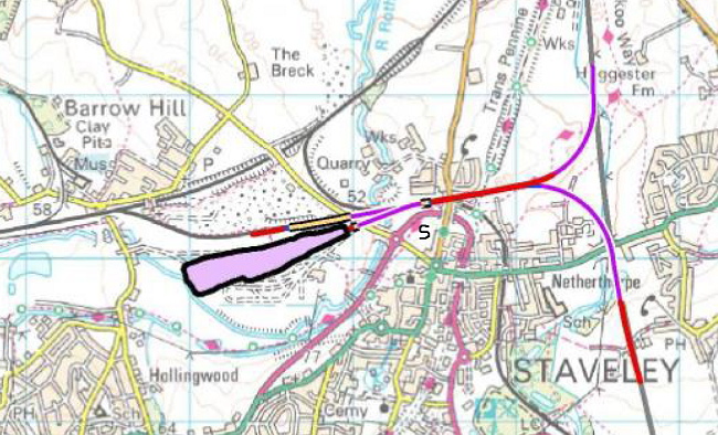
The proposed HS2 route goes straight up the right. The Depot is in mauve. Staveley Town Basin should be where we have drawn an S, virtually in the middle of the map. The Mill Green Link should head south west towards Hollingwood just below the River Rother. There is a gap in the canal just above where Hollingwood is written. This gap was removed when the canal was dug out in 1991 following opencasting. The pink road going south west from the Basin is the Staveley Loop Road Phase 2. It does not exist, indeed Derbyshire County Council has not even determined a route for it yet.
We must point out that the equivalent map in the HS2 Command Paper, which was laid before Parliament on 28th January, does not show the Loop Road Phase 2. However the other mistakes are still there. We would love to provide a link to the Command Paper, but it crashed on the first afternoon and has not been available since. Click here to see if it is back online. You could always look at the condensed (108 page) version by clicking here.
In 1769, John Varley walked or rode the entire length of the canal before producing a map to show to Parliament. This was for a project expected to cost £95,000. It is a shame that no one seems to have set foot in Staveley for a project expected to cost £33,000,000,000.