

28th January 2013
The Government today revealed its proposed route for the High Speed Rail link between Birmingham and Leeds. This goes through Renishaw and Killamarsh. Furthermore, there is a proposal for an infrastructure maintenance depot at Staveley. The line to this depot would run within a few metres of the new Staveley Town Basin.
The HS2 and depot line routes intersect with the proposed restoration route of the canal at the following points:
1. Between the new Railway Lock (5B) and the western end of Staveley Puddle Bank.
2. The eastern end of Staveley Puddle Bank.
3. Between Hague Bridge and Barlborough Road Bridge.
4. The Brindley Loops.
5. The northern end of the Railway Mile from Boiley New Bridge to where the canal veers off east just before Killamarsh Station.
To see the relevant sections of the HS2 route for yourself, click here for the Renishaw and Staveley sections; click here for the Killamarsh sections. To see the whole caboodle, click here.
To see the existing Chesterfield Canal Partnership restoration plans, click here and then click on numbers, 1, 2, 3, 4 and 5.
The route continues towards Sheffield alongside the River Rother all the way to Treeton. This covers two thirds of the route of the proposed Rother Link.
Natascha Engel is the MP for North East Derbyshire within whose constituency all these affected areas lie. Her website has the following quote.
“HS2 is an exciting opportunity for investment and jobs, but we need to look at the details to ensure that local communities are as little affected as possible.”
“ Like everyone else I have only just seen the details of the proposed route of HS2 and how it will affect North East Derbyshire. I know that there will be many people within my constituency in areas such as Staveley, Barrow Hill, Mastin Moor, Renishaw and Killamarsh who will be very worried about the proposals. HS2 is a massive project which will affect not just towns and villages in North East Derbyshire but also the Chesterfield Canal regeneration project. I will be holding consultations in the affected areas to ensure that I can take people’s concerns directly to government.”
The Trust has not had time to take any official position, but it seems abundantly clear that today is a key date in the history of the restoration. Compared to the £33 billion cost of the scheme, the amount needed to fit our canal restoration into the plan is completely trivial. Yet it would help to mitigate the desecration elsewhere of lots of natural beauty. It seems a no brainer to us.
Watch this space!
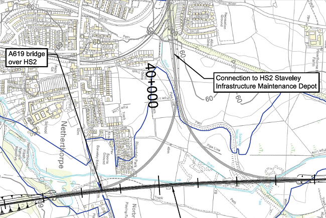
This extracted map has West at the top!
It shows the main route at the bottom and the lines to Staveley going up. The map stops just before Staveley Town Basin which is the other side of Eckington Road, the one coming from the right.
The embankment coming up from the bottom right to the middle of the map is Staveley Puddle Bank. The blue line along the bottom of the map is the River Doe Lea. Thus the HS2 line crosses virtually on top of the aqueduct that will take the canal over the Doe Lea.